Severe thunderstorms remain in the forecast for later today in a good part of Iowa.
Anyone with outdoor plans through this weekend will be vulnerable to hazardous weather. Have a way to receive warnings and know where shelter is available.
The highest chance for severe weather today is from 5pm-12am with large hail, damaging winds, and tornadoes possible.
Any storms before this time are expected to be non-severe.
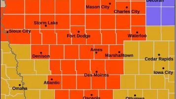
The Storm Prediction Center has a Slight Risk for severe thunderstorms for most of Hancock, southern Cerro Gordo, all of Franklin, most of Butler, and all of Wright, Hardin, and Grundy Counties for today.
An Enhanced Risk for severe storms covers the southwestern part of the state for today.